GENERAL
How to be a Good Guest
Where is Bat Cave?
The AREA
Area rock Layers
Topography
Geomorphology
Geological History
The Paleozoic
The Mesozoic
The Cenozoic
Water
The Hydrologic Cycle
Solution
Solution chemistry
Karst Landscapes
Erosional Features
Depositional Features
Environmental Issues
BAT CAVE
How was Bat Cave formed?
Surface Plan of the site
Map of the Cave
Life in and around Bat Cave
A Virtual Trip Through Bat Cave
TEST YOUR KNOWLEDGE
 What are the Effects of Solution?
1. It erodes (wears away) the land.
The net effect of all this solution is that it lowers the land surface
at an average rate of about 2 inches /1000 years. This does not sound like
much, it's only a foot every 6000 years. The area around the cave is less
than 100 feet above sea level. If present rates of lowering were
constant, it would only take a little over a half million years to
bring the area around the cave down to sea level. If we think of
the Newberry area as being a young person 20 years old ( and geologically
speaking Florida is young) its projected life expectancy would be a mere
3 months.
2. As it erodes land, it creates a unique landscape called a Karst
Landscape
A karst topography is any topography or landscape that has developed
by ground water erosion. It is characterized by
1. caves (underground cavities either above or below the water table),
2. sinkholes (depressions in the surface),
3. solution valleys (merged sinkholes) and
4. disappearing streams. (streams that flow at the surface for a while
and then flow into a sink).
5. lack of surface drainage. In areas where the cover over the
limestone is permeable the water infiltrates the sediments and there may
be no surface drainage at all.
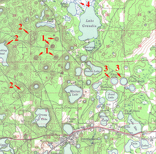 This
is a section of the USGS 15 minute 1949 Interlachen quadrangle.
This
is a section of the USGS 15 minute 1949 Interlachen quadrangle.
#1 on the map indicate four of the many sinkholes that dot the landscape
#2 are solution valleys or basins
#3 are solution lakes, that occur whereever the sinkholes are deeper
than the watertable.
#4 is a large solution basin that has been invaded by vegetation to
form a swamp.
Note the complete absence of streams in the 25 mi2 area
depicted.