GENERAL
How to be a Good Guest
Where is Bat Cave?
The AREA
Area rock Layers
Topography
Geomorphology
Geological History
The Paleozoic
The Mesozoic
The Cenozoic
Water
The Hydrologic Cycle
Solution
Solution chemistry
Karst Landscapes
Erosional Features
Depositional Features
Environmental Issues
BAT CAVE
How was Bat Cave formed?
Surface Plan of the site
Map of the Cave
Life in and around Bat Cave
A Virtual Trip Through Bat Cave
TEST YOUR KNOWLEDGE
 GEOMORPHOLOGY
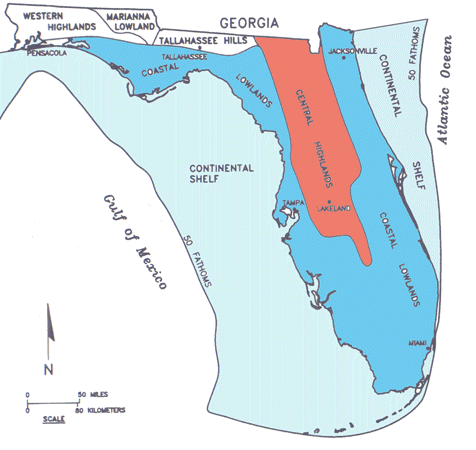 |
Bat Cave lies in North Central Florida, in the Central Highlands
of the Atlantic Coastal Plain (in red on the map) between the Northern
Zone and the central Mid-Peninsula Zone.
(Map modified from White, 1964, 1970; Randazzo and Jones, 1997). |
| . | |
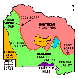 |
The general county topography is one of a lower, relatively flat
limestone plain in the West and South, (in green on the map) and a relatively
flat upland terrace, the Northern Highlands, (in pink on the map) in the
North and East. The edge of the terrace is clearly delineated by the westward
and southward-facing Cody Scarp. In the westernmost part of the county,
including the Bat Cave area, land rises again in the Brooksville Ridge.
(Map modified from Hoenstine et al.,1990) |
| The basic underpinnings of Florida are carbonate rocks,
deposited on a shallow platform over tens of millions of years. These
carbonates (mainly limestones and dolomites) formed in a warm shallow sea
much like the Bahamas today, and form a major sequence of rocks, the youngest
of which is the Ocala Limestone which is close to the surface in many areas
of this region.
The later evolution of the Florida landscape and especially its karsification has had much to do with the tremendous climatic changes that took place during Cenozoic time. The Oligocene marked the beginning of a world wide cooling trend in the climate with the onset of a major glaciation in Antarctica. Later these glaciers will cover Greenland and eventually, in the Pliocene and Pleistocene will spread across North America and Europe and grow on mountain chains such as the Appalachians, Rockies, Alps and the Himalayas. In this area, most of the Oligocene of Florida is gone, eroded by runoff and chemical action of infiltrating waters. Extensive dissolution within the exposed Eocene and older limestones later led to the present karst landscape. Miocene and later rises in sea-level led to the infilling and recovering of many of these karst features. Others filled in with sediments that washed in later. Frequently these infillings contain fossils that provide us with a great record of past life in Florida. |
|