 |
BACK | NEXT |  |
|
|
STUDY QUESTIONS |
|
|
BACK | NEXT | |
|
|
STUDY QUESTIONS |
|
It is a geological truism that streams have created and changed the valley in which they flow. If stream erosion is confined to the channel in which it flows, then how do streams change their own course and affect the surrounding landscape? They do this in three ways, by deepening, lengthening and widening their valleys. Headwaters are commonly areas of erosion dominated by downcutting. As the water rushes downhill, the channels are mostly straight, narrow and V-shaped. Because the stream has not removed harder materials in its channel, there are still rapids and waterfalls. Downcutting lengthens the valley headward. As the channel deepens, new materials are brought to the stream by mass wasting and the valley widens. New tributaries form along the course of the original valley and contribute their waters and load of sediments. |
|
 Over
time, as the gradient of the stream decreases, downcutting also decreases.
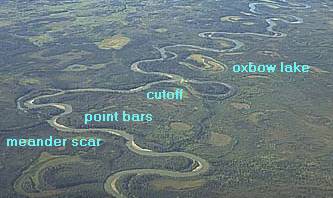
As the stream adjusts to its new transport role, it begins to meander (curve).
Because the water moves from side to side along these meanders, it erodes
the banks of the channel rather than the bottom. Sidecutting increases,
the valley widens and a flood plain develops. One way of looking at the
flood plain, is to consider it the high water channel of the stream. Over
time, as the gradient of the stream decreases, downcutting also decreases.
As the stream adjusts to its new transport role, it begins to meander (curve).
Because the water moves from side to side along these meanders, it erodes
the banks of the channel rather than the bottom. Sidecutting increases,
the valley widens and a flood plain develops. One way of looking at the
flood plain, is to consider it the high water channel of the stream.
|
|
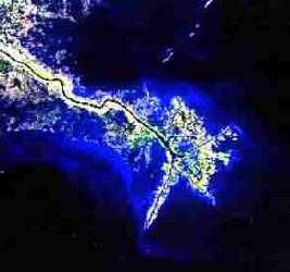 Ultimately, as the water reaches the sea, it loses its energy and the fresh
water mixes with seawater. Sediments settle out in the quieter offshore
zones. The coarser sands settle out first. The finer sediments are carried
farther offshore before they in turn settle to the ocean floor. If deposition
takes place along a high energy coast, the sediments are scattered by shoreline
processes and the river ends in an estuary. If lower energy conditions
predominate, the sediments accumulate at the mouth of the river forming
a delta. It is reasonable to envision that if erosion and deposition were
to continue unabated, the ultimate landscape would be low, with little
or no relief, a peneplain from which would rise an occasional isolated,
low mountain of less easily eroded materials, a monadnock
Ultimately, as the water reaches the sea, it loses its energy and the fresh
water mixes with seawater. Sediments settle out in the quieter offshore
zones. The coarser sands settle out first. The finer sediments are carried
farther offshore before they in turn settle to the ocean floor. If deposition
takes place along a high energy coast, the sediments are scattered by shoreline
processes and the river ends in an estuary. If lower energy conditions
predominate, the sediments accumulate at the mouth of the river forming
a delta. It is reasonable to envision that if erosion and deposition were
to continue unabated, the ultimate landscape would be low, with little
or no relief, a peneplain from which would rise an occasional isolated,
low mountain of less easily eroded materials, a monadnock
Satellite photo of the birdfoot delta of the Mississipi River |
|
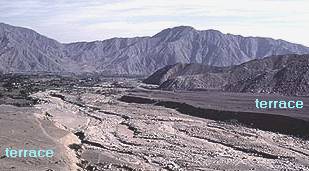 However,
the earth is still an active planet. Inevitably, uplift or subsidence,
or rises and falls in sea level introduce disequilibrium. As land rises
or sea level drops, streams begin a new cycle of erosion. As streams adjust
to their new conditions, they once again modify their course and sediment
load. Incised meanders are produced when renewed downcutting proceeds more
rapidly than sidecutting. Conversely, if sea level rises or the continent
is depressed, streams deposit. However,
the earth is still an active planet. Inevitably, uplift or subsidence,
or rises and falls in sea level introduce disequilibrium. As land rises
or sea level drops, streams begin a new cycle of erosion. As streams adjust
to their new conditions, they once again modify their course and sediment
load. Incised meanders are produced when renewed downcutting proceeds more
rapidly than sidecutting. Conversely, if sea level rises or the continent
is depressed, streams deposit.
Often this record of change can be read as terraces, either erosional or depositional, which form as the stream abandons one floodplain to form a new one, at a higher or lower elevation. |
|
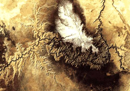 The
Grand Canyon, seen in the satellite photo at left, is such a stream. Originally
a mature stream flowing on top of the Colorado Plateau, the Colorado river
began downcutting when the area was uplifted by about a mile, creating
a canyon with incised meanders The
Grand Canyon, seen in the satellite photo at left, is such a stream. Originally
a mature stream flowing on top of the Colorado Plateau, the Colorado river
began downcutting when the area was uplifted by about a mile, creating
a canyon with incised meanders |
|